History of Freeman's Wood
A SHORT HISTORY
The site now commonly referred to as Freeman’s Wood adjoins what used to be part of a linoleum factory, and is now Lune Industrial Estate. It is close to the River Lune and is part of land which was known as Lancaster Marsh Estate.
This land was once under the control of Lancaster Corporation but was sold over 100 years ago.
In the 18th century Lancaster Marsh was common pasture land on which the 80 oldest freemen of Lancaster had grazing rights. It was enclosed by Lancaster Corporation in 1796 and divided into fields which were rented out. Legislative Acts of 1864 and 1892 gave the Corporation power to sell parts of the Marsh.
Williamson’s lino factory was created nearby in the mid 19th century and, as it gradually expanded, Williamson bought additional plots of land, including Freeman’s Wood. Part of this plot was used as a factory tip, one area included a gravel pit, and part was a recreation ground for the factory workers.
In its heyday, Williamson's was a huge factory and major employer, but it declined in the 1950s and 60s. The whole factory site, then known as Lune Mills, was sold in 1969, and part of it became Lune Industrial estate in about 1972. The factory continued to operate under new names and owners, but ceased in 2001.
Industrial use of Freeman's Wood diminished as the factory declined, but recreational use continued, and local people have apparently been using it since the 1950s. Most of it was fenced off between November 2011 and January 2012.
A MORE DETAILED HISTORY
Up to the 18th Century
The site currently known as Freeman’s Wood is close to the tidal reach of the River Lune. This river has been most significant to the history and location of Lancaster, as a strategic position for a roman fort, a river crossing, and an important port in the 18th century.
The Freeman’s Wood site is part of an area which used to be called Lancaster Marsh. This was a stinted pasture, that is common land with grazing rights defined for a fixed number of animals (e.g. one stint = one ewe with lamb, four stints = one horse, etc.). In the 18th century the eighty senior resident freemen of Lancaster were entitled keep a limited number of livestock there, and to have an equal share in the herbiage and net income arising from this ground.
The “Enclosure of the Commons Act” of 1795 allowed Lancaster Corporation to 'enclose' the land, to divide it up into fields, and to rent it out to private tenants. The freeman’s grazing rights were removed, but the rent was used to pay them “Marsh grass” money, a custom which still continues.
Williamsons Lino factory
James Williamson Snr established a coated fabrics business in this area in the 1840s. He died in 1879 and his son James Williamson Jnr. took over the business and expanded it rapidly in the 1870's. Having started on the site of a shipyard by the river quay, Williamson’s Lune Mills Factory gradually took on more of the Marsh, buying additional plots in stages, and grew to cover twenty-one acres, including the area now known as Freeman’s Wood.
There are some excellent aerial photos of the Lune Mills factory and surroundings in the 1920s, in 1932, and several in 1949, see below.
The main product of Lune Mills was lino. This was a huge and very successful factory and it had a dramatic effect on the area, providing jobs for many local people. James Williamson became Lord Ashton, and was one of the richest men in the world at that time. He died in 1930, aged 88.
His daughter Ella and her husband Earl Peel then formed a private limited company, James Williamson & Son Ltd, and in 1947 the company became a public limited company. The company celebrated its centenary in 1944 but it began to decline in the 1950s. In 1963 the company was merged with Michael Nairn & Co of Kirkcaldy to form Nairn Williamson Ltd. The Nairn-Williamson group was bought by Unilever in 1975, and sold to Forbo SA, a Swiss company, in 1985. It became Forbo-Lancaster Ltd in 1993, and in 2001 H-A Interiors (part of a German company Hindrichs-Auffermann) bought Forbo-Lancaster. At the end of that year the Lancaster factory closed altogether.
All that remained of this once hugely successful business and Lancaster's largest employer, were derelict factory buildings. With many of the buildings already demolished, the remainder of this once busy site now lay derelict, overgrown, vandalised or collapsed. The whole site was cleared in 2013-14 and house building started in 2014.
Freeman’s Wood - The path to the river
The name “Freeman’s Wood” originally applied to a tree-lined path which runs from the end of Willow lane to the river Lune. This path with tree symbols along it is shown on Greenwood’s Map of Lancashire of 1818. The earliest Ordnance Survey 6 inch map for this area published in 1848 shows it labeled as “Municipal and Freeman’s Wood”. The earliest OS map at a scale of 25 inch to the mile, surveyed in 1890 and published in 1891, also labels the path as Freeman’s Wood, with tree symbols.
Press reports from the 1880s/1890s refer to the ‘road’ through Freeman’s Wood to the river embankment and to the planting of trees along it by the corporation and the maintenance of the embankment, the ‘road’, and footpath. There are references to the people of the area using it for recreation. The publican at Snatchems, a pub on the opposite side of the river, used to provide a ferry to link to the end of the wood.
After the death of James Williamson / Lord Ashton (see below) the Corporation retained not only the wood/path but a strip of land to the east of the wood since it wished to retain the option of building a road from the end of Willow Lane / Westbourne Road out to the New Quay alongside the wood.
Freeman’s Wood – a larger area
The name “Freeman’s Wood” is now used for a larger area. The most common current usage of the name, and the most inclusive, is for the area marked on Google Maps, and covered by the Tree Preservation Order imposed by Lancaster City Council in December 2011. The TPO refers to this as the area “commonly known locally as Freeman’s Wood”. Its area is estimated as 28 acres (11.3 ha)
This plot of land is bordered by the Lune Industrial Estate, a cycle path from the end of St George’s Quay (New Quay Road), the footpath leading from Willow Lane to the river, Willow Lane itself, and a playing field (Coronation Field).
Along the east, south, and west sides are belts of woodland and scrub. The middle part of the plot is open grassland with some scrub.
Use of this land – records, maps, and aerial photographs
The 1848 Ordnance Survey map show this area marked out in rectangular field plots, possibly drained. On the earliest OS map at a scale of 25 inch to the mile, published in 1891, the land is named as being part of Lancaster Marsh. The London and North Western Railway Glasson Dock Branch railway is shown.
A plot of land near Willow Lane included a 'gravel pit'. This is now the triangle of woodland near Willow Lane, still owned by Lancaster City Council.
There are some excellent aerial photos of the Lune Mills factory and surroundings, including the plot now known as Freeman's Wood, in the 1920s here, in 1932 here and here, and several in 1949 here, here, here, here, here, and here.
After purchasing it, this land was used by Williamsons as a tip for waste from the works, and also as a sports ground, with the entrance off the end of the quay with a cricket field and football pitch. The trees on the Freeman's Wood path ran along the edge of this area.
The 25 inch OS Map of 1957 shows a cricket pitch, with pavilion, and a football ground, with access from Brockbank Avenue on Williamson's industrial site. The rest of the site is railway line, and to its east appears to be a waste area.
The neighbouring Coronation Playing field was laid out on remaining council land by local people, who raised the finances and did all the necessary work. It opened in the jubilee year 1953, hence its name.
The Glasson Dock railway line divided the site until it was closed and removed in 1964, so access from Willow Lane and Coronation Field would have been restricted for local residents until this was removed.
A black and white aerial photograph taken in the 1960s shows the Freeman’s Wood site with the cricket and football pitches, and an area to the west which might be a factory tip area, plus an area to the east of the railway line which also seems to have an industrial use. Aerial photographs taken in the late 1980s clearly show the cricket and football pitches apparently maintained as mowed areas, indicating that they were still in regular use.
In an aerial photograph of 2000 the football and cricket pitches are less clearly visible, suggesting that they were no longer maintained as such. These pitches are still visible in an aerial photograph of 2003 but do not appear to be in use or maintained for their original purpose. There is more tree growth around these areas.
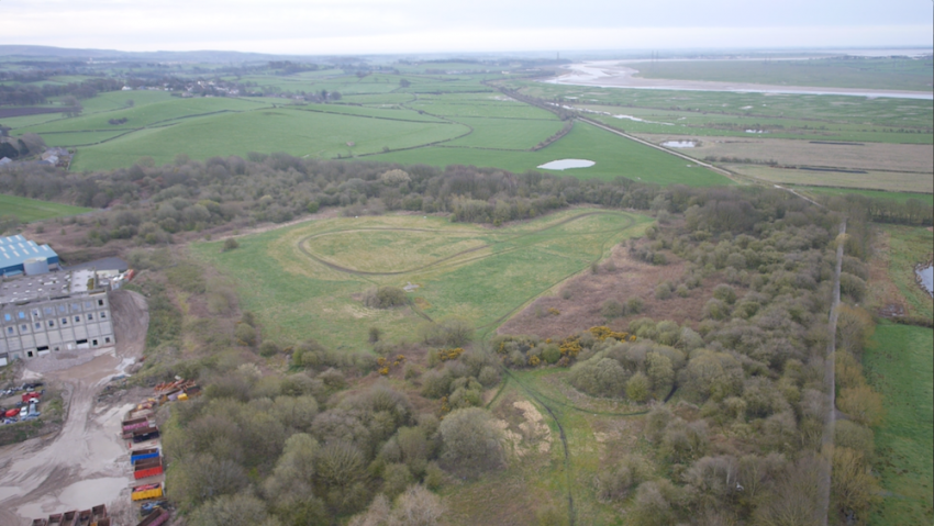
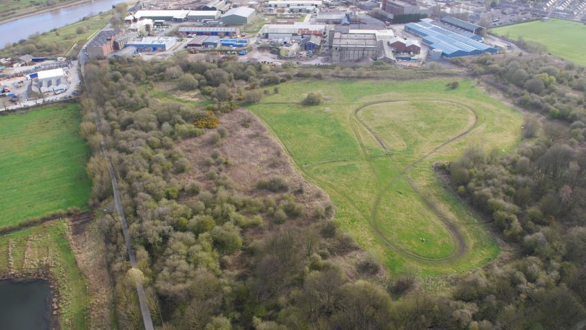
The use of the site appears to have changed by the time of an aerial photograph of 2006. The cricket field and football pitch are no longer marked but their area was clearly being used as there are a number of worn tracks on and around them, possibly for bikes, and in an aerial photograph of 2010 a figure of 8 track across the old cricket and football pitches is much clearer.
Use of this land - Views of members of the public
Local legend suggests that James Williamson gave this land to the local people, but this is not clear. However, the land has been used by local people for decades, some say as much as 60 years.
The Friends of Freemans Wood and Coronation Field claim that the whole of this area is much used and loved. Before the fencing was installed three distinct footpaths created by generations of use by local people from 1905 ran across the site. The woodland areas along the south and west areas had an extensive network of paths through them. The south-western corner had a BMX cycling track on it with numerous ramps and obstacles constructed by local parents and children over many years using pallets and dug earth. The open grassland in the middle was used as a football pitch and part as a cricket pitch.
Locals had also built hides to watch the rich and varied wildlife and birds. This site is a mixed mosaic of habitats, and one important pastime was bird-watching. Examples of species observed include grasshopper warbler, blackcap, lesser whitethroat and whitethroat. This area provided a route for roe deer to move from the estuary across onto the fields to graze.
Downstream the river Lune widens to become a broad estuary with mudflats and saltmarsh flowing into Morecambe Bay. The Lune estuary is a Site with Special Scientific Interest.
The land was a quiet oasis and a 'green lung' in an area close to an industrial estate, a Council housing estate, and a large area of terraced houses without gardens.
The local community was outraged by the fencing of the land. People state claim that they had never been stopped from going into the site or warned about using it until the fencing was installed between November 2011 and January 2012
Some trees were damaged when the fencing went up, and Lancaster City Council then imposed a Tree Protection area on the whole site. This TPO was challenged by the owners but was upheld.
Local people made applications for Town Green status for the site and for three Designated Footpaths across it.
73 people completed and submitted Town Green forms. These individuals claimed to have been using this land for between 2 and 64 years, with an average of 19.53 years.
36 people completed and submitted evidence questionnaires in support of an application for designation of 3 footpaths across the land. These individuals claimed to have been using this land for between 2 and 63 years, with an average of 21.42 years.
These individuals stated that they had used the land for a wide variety of activities including dog walking, walking, children playing, picking blackberries, picnicking, nature watching, BMX riding, running, and cycling.
The majority of the people who provided evidence statements state that they had never seen any signage or other indications that crossing the land would be trespassing, until the fence was erected in late 2011. A couple of evidence statements suggest that some signs were displayed about 5-7 years ago, but these apparently disappeared within days of being put up.
Use of this land - views of the owners
The owners claim that use of the cricket and football pitches in the 1960s to 1980s was not by the ‘public’, but by local clubs with permission from the landowners. A former manager at the factory has stated that part of the site was once the Sports Ground of Nairn Williamson Limited and Lancaster Cricket Club. The pavilion remained until it was demolished in November 1997 for health and safety reasons after not having been used for many years.
This manager stated that measures were put in place at various times over the years to stop travellers moving onto the site. On a number of occasions fencing was erected with signs stating that the land was private property and that public access was not permitted. On each occasion the fencing was vandalised and signs were destroyed. He remembered arranging for damage to the fencing around the site to be repaired in April 1998 and again in January 2004. Signs warning that the site was private land, and that access was only permitted with permission, were erected at the same time. While it had been used by dog walkers, efforts were continuously made by the owners to prevent such unauthorised use of the site, but fences were regularly vandalised and damaged to allow continued unauthorised access onto the property.
The Land Owners
The land now known as Freeman’s Wood was part of Lancaster Marsh and belonged to Lancaster Corporation. The Marsh Act of 1864 and a further Act of 1892, gave the Corporation power to sell some of the Marsh.
A railway line constructed in 1883 ran through Williamsons factory and this site from Lancaster to Glasson Dock, owned by London North Western Railway Company.
Freeman’s Wood was sold by Lancaster Corporation to Williamson in stages. The main area west of the railway line, in 1896, an extra strip around this in 1903, and that east of the railway in 1906.
Following the decline of Williamsons, and the first company merger in 1963, all the land of Lune Mills was sold in 1969 to Mount St Bernard Trusts Ltd. The company then rented back the land it wanted for its continuing industrial manufacturing. Lune Industrial Estate was created about 1972 from part of this land.
The Lune Mills land seems to have changed hands several times, with owners being named as Royal Exchange Assurance, Mount St. Bernard (Securities) Ltd, Bayeast Property Company (both at 54 Grosvenor St London W1). From 1986 to 1997 it was apparently owned by Lune Condale Properties Limited and Shiregreen Property Co. Limited
The Property Trust Plc was generally stated as being the owner of most of Freeman’s Wood at the time of the project, and was represented by Satnam Investments Ltd. However, the Land Registry documents gave the owner as Lune Industrial Estate Ltd, and that it had purchased this land in 1994.
Lancaster City Council owns the small triangle of land adjoining this plot, Willow Lane, and Coronation Field recreation ground.
Freemen and their Property Rights
Freemen were initially the burgesses of a town. By the 17th century, freedom of the borough was not restricted to ownership of burgage property but could be acquired by birth (ie son of a freeman), by apprenticeship to a freeman, or by purchase or gift, ie bestowed by the borough, as it still is for honorary freedom. Freemen had special privileges such as the right to trade in the market without paying fees, and were also the only people who could vote in national elections before 1832 when a form of ratepayer suffrage was added. They also benefited from the resources owned by the corporation such as the grazing on the commons. In Lancaster this included the Moor and the whole of the Marsh, until the corporation obtained powers to divide and later sell it.
The draft Lancaster Corporation Act of 1880, reported in the Lancaster Gazette, sought to abolish freemen's property rights on the Marsh, but the freemen petitioned against this proposal and took their case to the Select Committee of the House of Lords. The annuity is still paid to the oldest 80 freemen today.
Lancaster Corporation / Lancaster City Council
The Lancaster Corporation Act of 1900 required that most of the land now known as Freemans’ Wood be used for public recreation and allotments.
The Act, particularly part V sections 66(1), 67, and 70, refers to the Corporation's responsibility towards the Marsh.
“So much of the Marsh being not less than 40 acres shall be appropriated by the Corporation for the purposes of a public recreation ground and for allotments. Provided that at no time shall less than 30 acres be utilised for the purposes of a public recreation ground. Provided also that if at any time such allotments shall not be required the land not so required shall be utilised for ever as a public recreation ground.
The portion of the Marsh for the time being so appropriated for a public recreation ground shall be laid out, kept and maintained in such manner as the Corporation think best for the recreation and benefit of the inhabitants of the borough.
Subject to the provisions of this Act the Corporation may from time to time with the approval of the Local Government Board sell and absolutely dispose of all or any part of the Marsh not appropriated for recreation ground or allotments under the provisions of this Act.”
This act was amended by the Lancaster Corporation Act 1918 section 80 giving the council the power to sell lease or dispose of all of the land on the Marsh, including public recreation ground, if they so wished.
Future Plans
An undated Lancaster City Council planning strategy map has the whole area marked as ‘Regeneration Priority Area’. Luneside Industrial estate is marked as ‘General Employment Allocation’, and Freeman’s Wood as both ‘Willow Lane Opportunity area’ and ‘Amenity’.
Lancaster City Council draft Land Allocations Development Plan Document for 2003-2023 includes a proposed policy CWL5: "Land identified as Willow Lane / Coronation Field Opportunity Area on the Local Plan Policies Map is an area for recreation and open space improvement. The Council will support proposals that enhance and regenerate the quality and quantity of recreation and open space provision in this area".
References
Lancaster Gazette. 15 November 1879. 14 February 1880. 13 March 1880.
Report of the Town Clerk to the Finance Committee upon the rights of the Freemen in the Marsh Estate Lancaster. Borough Council; Roper, William Oliver (Town Clerk) Includes map of Marsh Estate as insert. Published Lancaster 1894
House of Commons Parliamentary Papers Online, Municipal Corporations in England and Wales. 1835. P1761
MARIO - Maps And Related Information Online: Lancashire County Council http://mario.lancashire.gov.uk/agsmario/marioguide.pdf
Dr Michael Winstanley, History Dept, Lancaster University - retired. Extensive personal communications.
Jon Barry, Lancaster City Councillor, Castle Ward. Personal communications.
Tracey Kennedy, Lancaster City Councillor, Castle Ward. Personal communications.
Emily Heath, Secretary, Friends of Freeman’s Wood and Coronation Field. Personal communications.
Catriona Stamp - personal communications.
Application document for Town Green status, plus supporting evidence forms 2012
Application document for Designated Footpaths, plus supporting evidence forms, and objection letters. 2012
Wildlife and Countryside Act 1981 Definitive Map Modification Order Investigation.
Applications for the Addition to the Definitive Map and Statement of Three Public Footpaths across Coronation Field, Lancaster City. Application Nos. 804-541, 804-542, 804-543 December 2014. (Note the name ‘Coronation Field’ seems to be an error.)
The Friends of Coronation Field and Freemans Wood https://www.facebook.com/SaveFreemansWood https://savefreemanswood.wordpress.com/
Virtual Lancaster http://www.virtual-lancaster.blogspot.co.uk/search/label/Freeman%27s%20Wood
Lancaster Guardian newspaper
Lord Ashton - the Lino King From a leaflet by Sue Ashworth produced by Lancaster City Museums. http://www.lancaster.gov.uk/council-and-democracy/civic-ceremonial/lord-ashton-lino-king/
Satnam Investment Group. Mixed Use Development, Lune Park, Lancaster. Outline Development Proposal. 2010 Report including a map.
Please Note
We would welcome any additional information, amendments, and corrections to the above account.

